


Hello Interactors,
I’ve been delayed getting this one out after being hit with a stomach bug. But I’m back in business and back to looking at urban behavior. This time, I dig into a power law that proves a Geographer right (again) while making the dizzying array of diversity in human urban mobility look shockingly similar.
As interactors, you’re special individuals self-selected to be a part of an evolutionary journey. You’re also members of an attentive community so I welcome your participation.
Please leave your comments below or email me directly.
Now let’s go…
A THEORY CENTRALLY PLACED
A few days after meeting with a group concerned with rapid urban development, I found myself in another meeting, in the same room, with a group who thinks it’s not rapid enough! Meanwhile, Washington state legislators are proposing and passing legislation aimed at addressing the impacts of increased population growth, housing shortages, and transportation.
We were meeting to discuss what kind of housing density and transportation infrastructure is necessary to get people walking, biking, or rolling within 10-15 minutes of their nearest store or transit stop. As I wrote last month, getting people to drop their car is easier said than done. For starters, people need jobs and businesses to walk to in the first place. However, businesses only thrive when there are enough customers to keep them alive. More potential customers walking, biking, or rolling only comes when there is more dense housing.
Like that found in downtown Paris. Over the last three years Mayor Anne Hidalgo has been made famous championing the 15-minute city concept. She’s restricted car use to certain areas and has built hundreds of miles of bike lanes. Her efforts made the Paris core so desirable property value increases started to squeeze poorer people out of the area. In response she built affordable housing.
However, just outside this urban core Paris continues to remain car dependent. The same can be said for Olso. In fact, despite 75% of Europeans living in dense cities, while also declining in population, their major cities continue to sprawl.1
There are many variations of land use and transportation configurations around the world, but they all emerge toward, or are influenced by, by central place theory. This concept was developed in 1933 by the German geographer, Walter Christaller and became influential in how cities were planned around economic activities.

To illustrate the concept, he drew an array of hexagons each with their own center around a center hexagon representing a core city center. Imagine a hexagonal flower. He used this diagram to then describe these three principals governing behavior within and between geographic regions:2
Consumer choice. Each of us have a choice to make around much time and money we’re willing to spend to arrive at a particular destination. Like any forager, we can choose the cheapest path at a risk of reducing our choices of goods or we can invest in a longer journey in exchange for more or better choices.
Firm agglomeration. A company offering goods to these consumers must decide whether to operate further away from their competition or cluster nearby. They’d be sharing more customers while also saving in delivery costs other economies of scale.
Functional hierarchy. As with natural systems, complex hierarchies emerge from these actions that are self supporting and become embedded in the environment.3 When governmental and commercial power is concentrated, functional hierarchies are strong. When power is diffuse and distributed individual agency weakens the hierarchy.
Christaller theorized that if a person within a hexagonal cell sought a good or service, they would first seek one within their boundaries if available. He added that if this cell happened to be the center cell, home to the densest population and services, the resident would rarely leave their own cell for routine activities. We’ll call ‘shopping within my own cell’ level-one.

If the service is not available within their hexagonal cell, they’d decide to go to next nearest cell with the available service. Let’s call that level-two. Those in level two most likely would go to the center cell, the city center, given it has the most consumer choice due to agglomeration. It is also relatively nearby.

Those living in level-three hexagons likely travel to the center cell for some activities and the level-two cells for others. Should they choose level-two instead of the center, more than one level-two cell may contain the same service within the same or similar distance. It’s assumed some of the people will choose one location some of the time and others the other location another time.

This model fits with my experience recently when our roof started leaking amidst a torrential downpour. Living in a tier-two area, I had two Home Depot stores equidistant from my home from which to purchase a pump. Each within their own tier-two areas featuring agglomerated retail.
I needed to quickly siphon swelling standing water from our flat roof that has recently acted more like a tub. The website said the one to the north had three pumps in stock, so off I went. Nope, there was no product to be found. So off to the one toward the south. They had one, though the website said they had none. My cost of travel more than doubled, but at least my drip stopped!
It was the ‘functional hierarchy’ of city planners, developers, and politicians that used central place theory to place these agglomerations of stores where they are. It’s the same theory used to decide where hospitals, fire stations, and Starbucks should go.
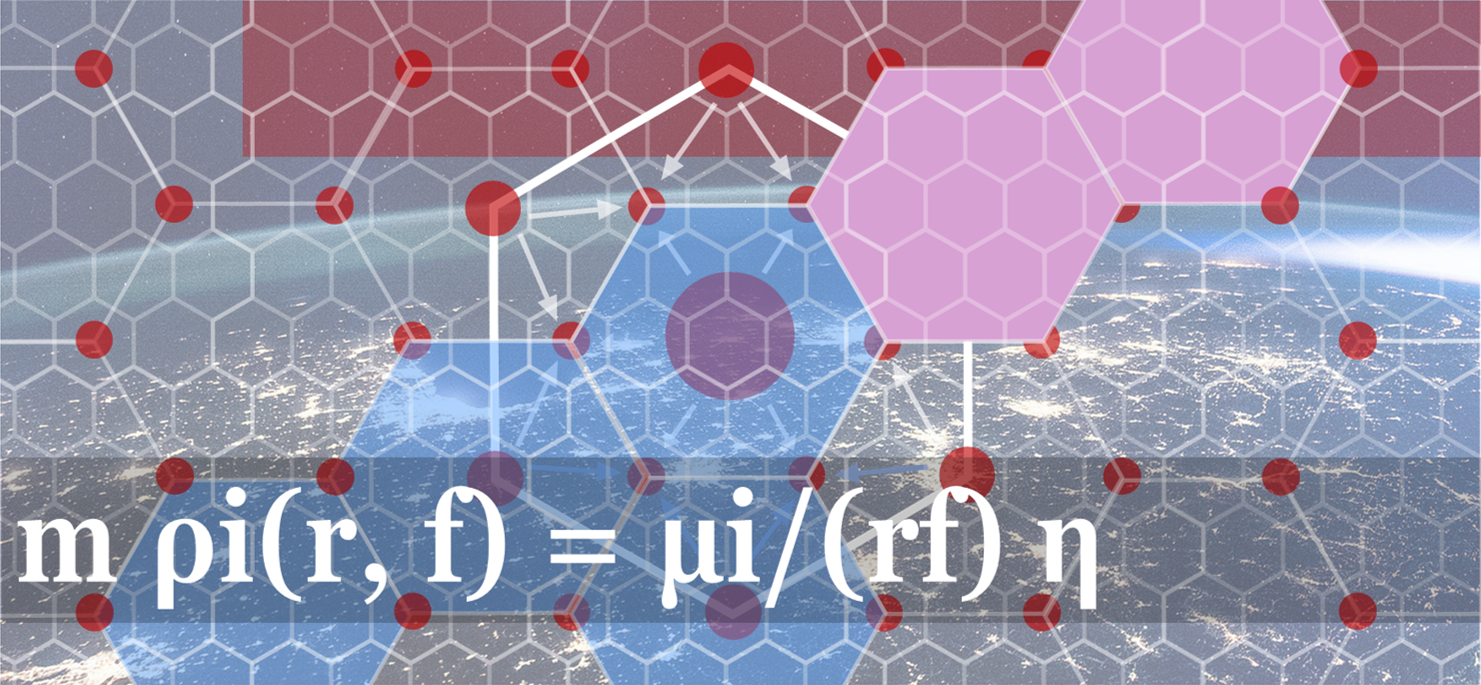
A LAW CENTRAL TO THE THEORY
For decades geographers and city planners have primarily used one of two laws to determine these locations and the movement of people between regional levels. One is called the gravity law and the other the radiation model. Both methods have a fundamental flaw in that they only consider aggregations of residents moving across the region. This doesn’t afford the ability to look at the frequency of individual trips to a given location. There are other models that look at fine grained behavior, but they lack the ability to then consider the patterns of the larger population.
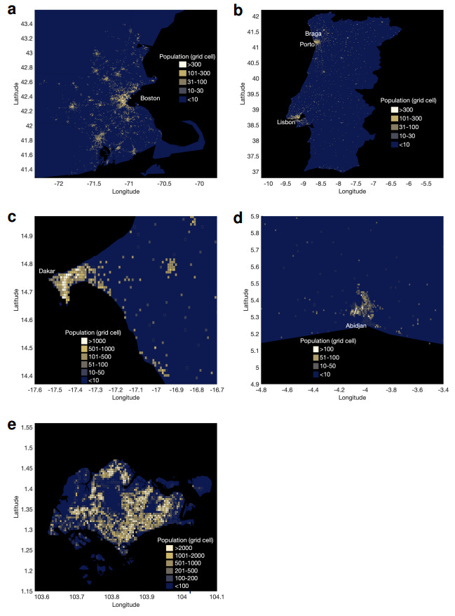
But in 2021, a group of spatial, urban, and complexity scientists landed on a preferred method. What they discovered is central place theory is more than a theory. Using anonymized cell tower time stamp data from cell phones, they were able to determine individual origins and destinations across a large region and population. They divided the study area into a grid and counted how many times people entered a given cell. This provided them with frequency of trips to and from various destinations – the granular data amidst an aggregate that has thus far been missing.
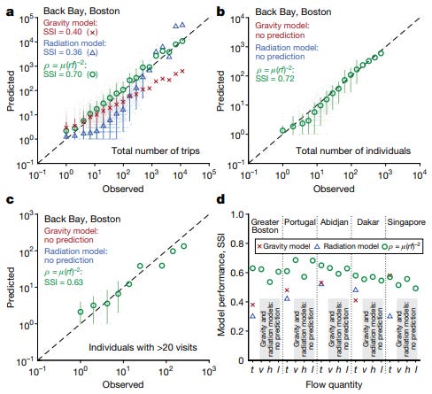
They found, with astonishing regularity, what Christaller assumed. Both frequency and distance to a destination are the sole determining factors in predicting behavior. For example, people travel a museum or mall less frequently and may travel a great distance to get there. Their data shows that not only are these special function locations visited less frequently, they address a larger radius of travel distances. The travel distance per visit is thus inversely proportional to the visitation frequency.4
The opposite is also true. Trips to more common destinations, like a grocery store or restaurant, are not only visited more frequently, but they are visited in higher numbers by those living nearby. Their data also supports Christaller’s notion of functional hierarchy. Travel between the various levels of hierarchy is supported by both consumer choice and the agglomeration of services. It also out performed both the gravity law and radiation model.
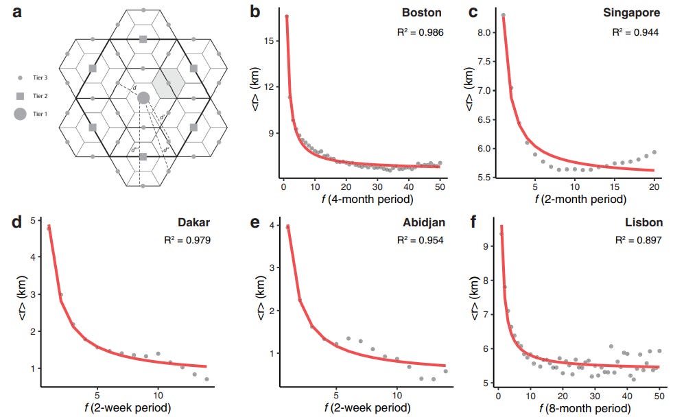
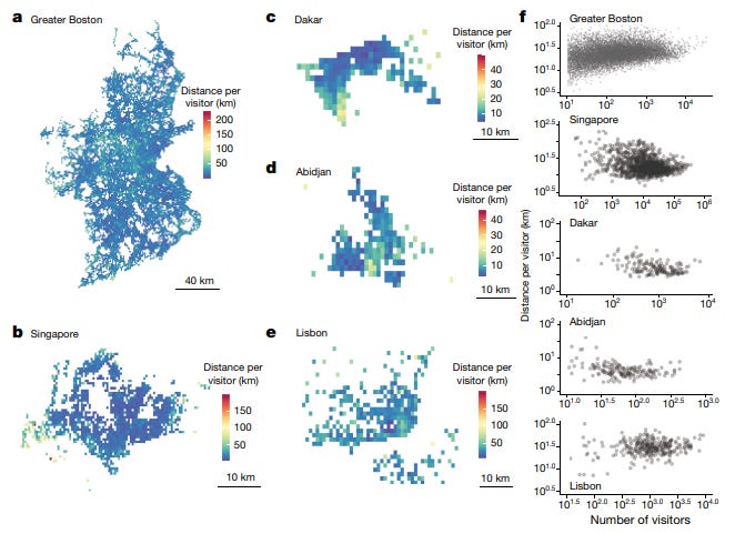
What is most miraculous is these findings are consistent regardless of the city scale or location. Singapore, Boston, Dakar, Lisbon, Toyko, New York, you name it, they all exhibit these universal visitation power laws. The results were so surprising it prompted the authors to state,
“Given the extensive literature on and detailed analyses of movement and transport in cities, it is surprising that the simple but powerful visitation law derived here had not yet been discovered.”5
It should be noted, however, not everyone can afford a cell phone. So, this data, and the power law, reflect the strong functional hierarchy embedded in our cities. That is, our cities have been planned and built by powerful functional social hierarchies that encourage clustering of businesses to efficiently allow for consumer choice for those with greater means. I wonder what patterns emerge for those without cell phones and less served by nearby services. It would sure raise questions of equity.
I’m also curious how this breaks down by mode of transportation. That is, how many trips were by car or transit and how many were by walking or biking. Their results are robust scaling from grid cell sizes 250m to 2km. Though they admit the model wouldn’t perform at smaller levels.6
Two-hundred and fifty meters is about three city blocks. That’s less than a 10- or 15-minute walk. The frequency law they uncovered would suggest if sufficient and attractive services were agglomerated within a short walk people would choose them for many trips over a further distance. But as Central Place Theory states, this requires sufficient agglomeration and density. The data reveals that sprawling Greater Boston has a wide distribution of distance covered to destinations relative to number of visitors compared to dense Singapore where the distance covered is more concentrated. If the data included elevation, it would reveal more Singaporeans also travel more up and down high rises for daily activities than those in Greater Boston! A vertical 10-minute neighborhood.
For a walkable 10-15 minute city or neighborhood to exist will likely require all three elements highlighted by central place theory. For walking to be a consumer choice, agglomeration is needed. The cluster of businesses can only be justified when there is a sufficient number of consumers. The only way consumer density can occur is if it is zoned and built into the fabric of the region’s functional hierarchy. Just this week the state of Washington passed a bill legalizing duplexes or fourplexes in areas historically zoned for single-family homes only. Should it become law, will it provide sufficient density to spawn a corner grocer, a neighborhood bakery, or hardware store? Or will the price of eggs, muffins, and lightbulbs keep people driving to Costco?
Lawmakers may hold the power to pass the laws, to strengthen the functional hierarchy which includes zoning for more density. We control our own consumer choice. But it will all come down to developers building density and firms agglomerating. Meanwhile, one law has been passed — the universal visitation power law of human mobility.
Determinants of urban sprawl in European cities. Walid Oueslati, Seraphim Alvanides, and Guy Garrod. Urban Studies. 2015.
The universal visitation law of human mobility supplementary information. Markus Schläpfer, Lei Dong, Kevin O’Keeffe, Paolo Santi, Michael Szell, Hadrien Salat, Samuel Anklesaria, Mohammad Vazifeh, Carlo Ratti, & Geoffrey B. West. 2021.
I wrote on embeddedness regarding Nike’s origin story in Eugene, Oregon.
The universal visitation law of human mobility. Nature. Markus Schläpfer, Lei Dong, Kevin O’Keeffe, Paolo Santi, Michael Szell, Hadrien Salat, Samuel Anklesaria, Mohammad Vazifeh, Carlo Ratti, & Geoffrey B. West. 2021.
Ibid
(2)


The Universal Uniformity of Urban Mobility