

Hello Interactors,
The horrific acts of violence in Palestine have prompted acts of violence on university campuses around the world. This post is about one thing they have in common — maps. Maps legally define territory, the rights of those who occupy it, and the rights of those in power to silence them, displace them, or ‘invisible’ them. A pattern we also see with America’s unhoused.
Let me try to map this out…
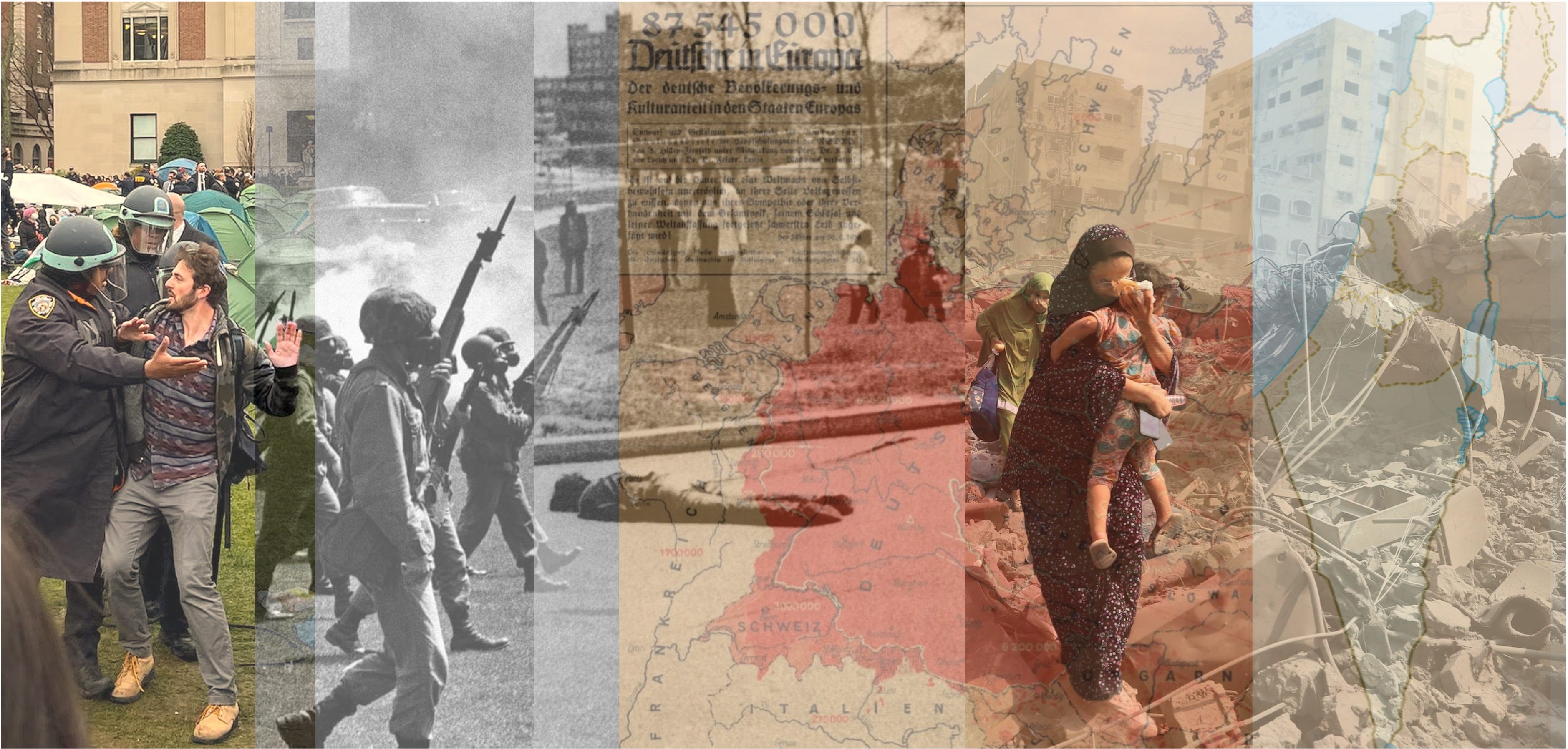
CAMPUS CONFRONTATIONS ECHO
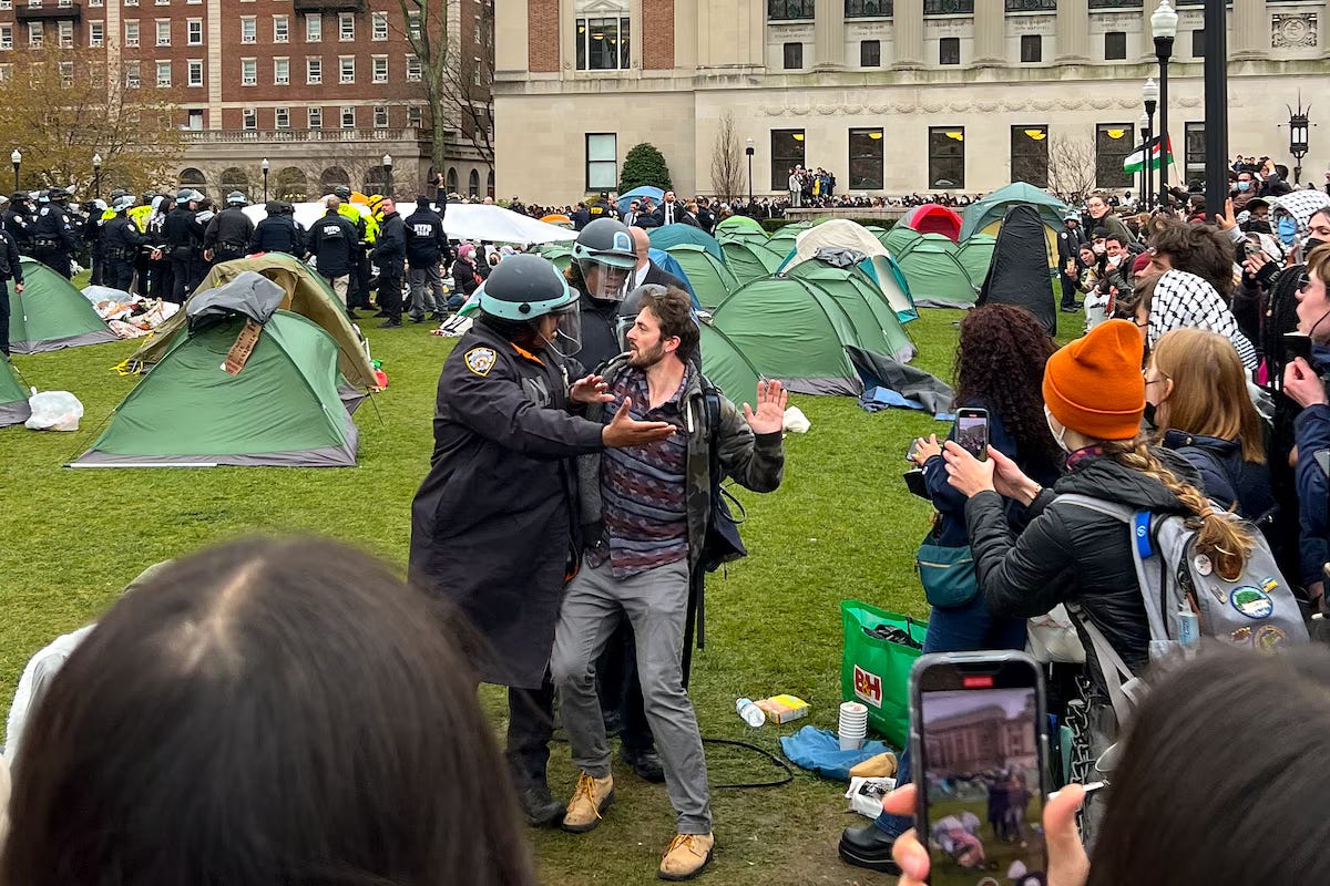
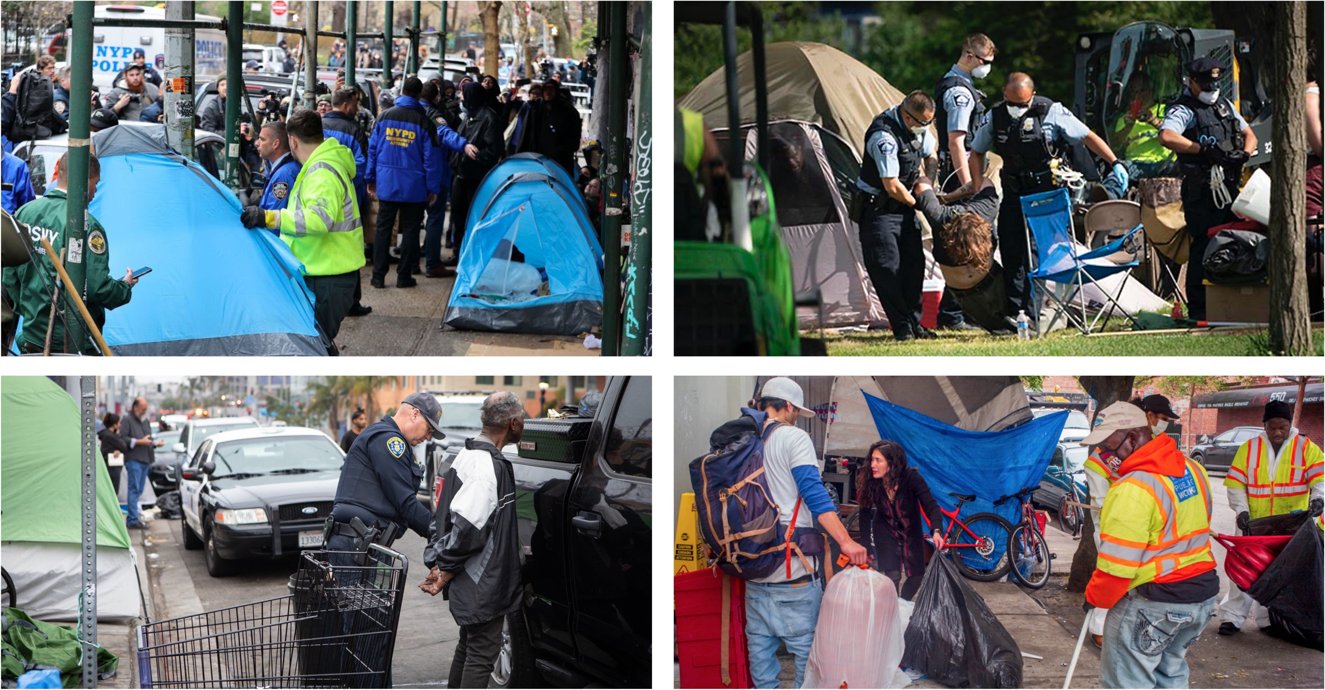
Citing "clear and present danger," Columbia University recently called for the New York Police to intervene. On April 18th, students had set up tents on a small patch of grass on campus — a form of protest calling for the university to divest from Israel due to the violence in Palestine. Despite the peaceful nature of the protest, the President of the school claimed their presence was menacing and that they were trespassing. Evidently, parts of campus are closed to students during certain hours. The incident resulted in the arrest of 108 students. But many returned and were joined by more upon their release.
Nearly a week passed before House Speaker Mike Johnson called on the school’s President to resign if she can’t suppress the war protests at her school. He went on to threaten federal funding for colleges that he sees are creating unsafe environments for Jewish students. Many equate opposition to the state of Israel as opposition of Jewish people.
Meanwhile, the Jewish Voice for Peace is claiming the university is making it unsafe for both Jewish and non-Jewish students in their actions. Of the 85 students suspended for protesting the actions of the Israeli state, 15 are Jewish. The Jewish Voice for Peace writes,
“Yesterday’s statement by the White House, like the administrators of Columbia University, dangerously and inaccurately presumes that all Jewish students support the Israeli government’s genocide of Palestinians. This assumption is actively harming Palestinian and Jewish students.”
Restrictions on student rights have also led to Jewish students being obstructed from observing their religious events and blocking access to their Jewish community.
Columbia University, named after Christopher Columbus and echoing his legacy of exploration and exploitation, has experienced similar conflicts before. In 1968, protests erupted over the university's plan to build a segregated gym, viewed as oppressive by Harlem residents. There was also significant discontent with Columbia's involvement with the Institute for Defense Analyses (IDA), a center providing support to the U.S. Department of Defense during the Vietnam War.
Columbia’s recent protests spawned more across the country. The National Guard have been called to many campuses to sweep protesters away echoing the deadly protests at Kent State 54 years ago. Or Yale in 1986 when police extracted a student who had erected a replica structure found in South Africa’s shantytowns protesting apartheid.
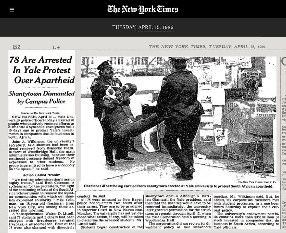
One student protester said at the time,
“We find the Administrations actions highly ironic in light of the continuing efforts of the South African Government to remove the squatter committees with which our shanties expressed solidarity.” In defense of the school, a spokesman said of the protesters, “No group is permitted to have a monopoly on the space.”
No group except, perhaps, the administration.
These university confrontations are part of a larger pattern of forceful takeovers and displacement evident in various forms, including the routine 'sweeps' of homeless encampments in cities across America. These sweeps often involve the removal of homeless individuals from public or private spaces, displacing them without providing long-term solutions to homelessness. Critics argue that such actions not only fail to address the underlying issues of poverty and housing insecurity but also perpetuate a cycle of displacement and marginalization.
Similar critiques are leveled against these universities who in many cases have been pressured by powerful donors and alumni to silence voices speaking out against the ongoing violence in Palestine. A pattern consistent with conservative efforts to squelch diversity, equity, and inclusion programs and the teaching of alternative views of history and race. Such actions also serve to perpetuate, and propagate, cycles of protest against oppression.
This practice highlights how power dynamics continue to affect those with less power. From students choosing to sleep outside in solidarity to the most vulnerable populations sleeping outside in poverty. It’s a self-enforcing system where those without property and/or rights are subjected to repeated eviction from their makeshift homes. In the case of those unhoused, it only serves to further entrench the disparities and social stigmas associated with homelessness. In this broader context, both the struggle over property at a university or an urban park reflect the ongoing contention over who has the right to occupy and claim space within our communities.

MAPPING AUTHORITARIAN DISPLACEMENT
These relatively small local campus disputes over territory and legality mirror the larger geopolitical conflicts over land, territory, and displacement they are protesting.
In the Levant or Ash-Shaam (ٱلشَّام ) region of the Middle East, the 1948 establishment of the state of Israel led to the first Arab-Israeli War. In the period from 1948 to 1951, approximately 688,000 Jewish people immigrated to Israel. Many of these were survivors of the Holocaust and from refugee camps across Europe, as well as Jewish refugees from Arab countries.
This period is known as the "mass immigration period" in Israeli telling of history. In Palestinian Arabic history this period is called "Nakba" meaning "catastrophe" or "disaster" referring to the mass displacement of Palestinian Arabs.
Here’s a short video from the Jewish Voice for Peace explaining how this early history has led to current events…including the role of maps.👇
For more history on international recognition of territories in the Middle East through maps drawn by European governments, check out my post 👇 from 2021 on:
Maps as Logos; Atlases that Impose

Hello Interactors, The shape of national maps are no accident. They’re not even natural. They’ve been created with intent. Yes, they represent political boundaries, but they also sell a brand. As interactors, you’re special individuals self-selected to be a part of an evolutionary journey. You’re also members of an attentive community so I welcome your pa…
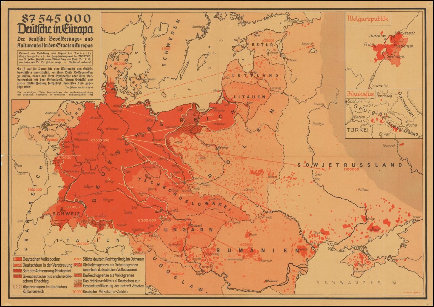
The mass displacement of Jewish people from Europe came as part of the Nazi’s European territorial expansion for resources called “Lebensraum” or “living space.” The term was coined by geographer Friedrich Ratzel in 1897 believing nations must expand their borders to acquire the resources necessary for their survival.
While written as part of a political geography text, it was a biological argument inspired by Darwinian theories of how species expand their habitats in the natural world. The concept had become a political weapon for German colonial expansion prior to World War II but was most exploited by Hitler.
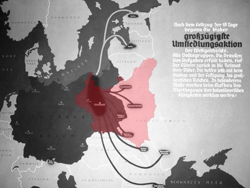
Cartography was integral to the Nazi ideology of Lebensraum, underpinning its aggressive expansionist policies with maps that were used to justify and facilitate the annexation of territories. Nazi cartographers produced maps illustrating overcrowded Germanic lands to rationalize the need for territorial growth.
Historical claims were visually asserted through maps highlighting ancient Germanic territories or regions with ethnic German populations, while ethnic and racial maps of Europe reinforced narratives of Germanic superiority and the 'right' to conquer Eastern European lands. Furthermore, detailed maps served as vital tools for the strategic military planning of invasions, outlining the logistics necessary to secure Lebensraum for the perceived future prosperity of the Aryan race.
Cartography facilitated the Nazi's economic exploitation of conquered territories and orchestrated the forced resettlement of ethnic Germans while planning the expulsion of others.
This manipulation of geographical information extended into the realm of propaganda, with maps depicting an expansive and resource-rich 'Greater German Reich' designed to instill a sense of national destiny among the populace. Cartography thus transformed from a tool of navigation and exploration into a mechanism of propaganda and oppression, actively contributing to the enactment of the Nazis' genocidal and imperialist objectives.
Left leaning political and ideological groups, including students, criticized the Nazi ideology of Lebensraum and other aspects of Hitler's regime. These groups were staunch opponents of fascism and were among the first to be targeted by the Nazis for suppression due to their opposition and potential to organize resistance against the regime.
In Alberto Toscano’s book, “Late Fascism: Race, Capitalism and the Politics of Crisis” he writes,
“Fascism faced the necessity of making a void around itself, of making a tabula rasa of every organized force, whether political or syndicalist, proletarian or bourgeois, trade unions, cooperatives, workers’ circles, Labour Exchanges.”
After Hitler's rise to power in 1933, the Nazi regime moved swiftly to neutralize all forms of political opposition. The Weimar Republic (1919-1933) was a period of significant political involvement for Jewish people in Germany. They were active in various political parties, including the Social Democratic Party (SPD) and the Communist Party of Germany (KPD), both of which had strong connections to labor movements and were integral to the republic's parliamentary democracy.
The KPD and SPD, and other leftist organizations were soon outlawed under Hitler, their leaders and members arrested, and their publications banned. The Nazis viewed the left as one of their main political enemies, associating them with Bolshevism, which they portrayed as a Jewish conspiracy against the Aryan race and the antithesis to their own nationalist and racial ideologies.
Within days of the Reichstag fire in February of 1933, an estimated 4,000 Communists were arrested. The ensuing months saw a dramatic escalation in the numbers of those arrested, with estimates ranging into the tens of thousands. By the summer of 1933, the number of political prisoners—Communists, Social Democrats, union officials, and other perceived or actual leftists—are reported to be over 100,000.
Many leftist leaders and activists were incarcerated in the early concentration camps, where they were subject to brutal treatment. The purges were not limited to the political elite; rank-and-file members of these parties, as well as trade unionists and others who represented the workers' movement, were also persecuted.
THE TERRITORIAL ROLE OF SOCIAL CONTROL
During the later stages of the regime, especially in the years leading up to and during World War II, the Nazis intensified their crackdown on any remaining leftist elements or dissidents, many of whom were sent to prison, forced labor camps, or executed.
Resistance activities continued, albeit at great risk, and those discovered were often summarily executed, particularly as the war progressed and the regime became increasingly paranoid and repressive.
Nazism managed to garner support from the German masses not solely based on pre-existing antisemitic and authoritarian tendencies, but rather through a systematic campaign that cultivated such ideas as part of a broader nationalistic and exclusionary ideology.
Hitler, effectively used propaganda, charismatic rhetoric, and the manipulation of societal fears and prejudices to gain political power. The Nazis' antisemitic and authoritarian doctrines were indeed not uniformly accepted across the entire population at the outset so he appealed to certain ideas and emotions within a diverse population. And Lebensraum was the pretense to spread these ideas and emotions throughout Europe.
The inherent racism, economic exploitation, and violent suppression of Lebensraum are hallmarks of colonial projects throughout history. Such historical and contemporary conflicts illustrate the painful reality of colonial projects, which are often marked by forceful takeovers and the displacement of people, revealing the stark power imbalances that still shape many societal and geopolitical structures today.
Cartography is a potent force, merging power with place. Maps do more than chart lands—they govern perceptions and control hierarchies. By defining territories, maps have historically empowered states over indigenous lands and interests, solidifying rulers' authority. Trespassing laws, working alongside maps, secure landowners' wealth and status, perpetuating a system that privileges property ownership above all else.
Legal instruments like maps once laid the foundations for empires, enabling harsh extractive economies. Their influence endures in today's urban design and surveillance, with satellite imagery and GIS optimizing resource control and shaping cultural views, often sidelining marginalized groups and deepening social disparities.
The current landscape of protest and civil unrest, as seen in the widespread student demonstrations calling for divestment and decolonization, reflects a continuation of this struggle over space and representation. When Columbia’s President invoked the specter of "clear and present danger" to dismantle peaceful protests, it was a stark reminder of the power that comes with controlling space.
The reaction of institutions across the globe, echoing Columbia's, highlights a pattern where those in authority use spatial control as a means to suppress dissent. The encampments, from New York to Sydney, stand as testaments to the resilience of those fighting for a fairer world, even as they face the prospect of being swept away by the forces of order.

As echoes of historical confrontations reverberate, from Kent State to the anti-apartheid struggles at Yale to present day Columbia — or past and present brutal bombings from Yemen to Ukraine or Pakistan to Palestine — they remind us of the stakes involved in the cartographic and legal delineation of our world.
These student movements illustrate the ongoing relevance of emancipatory theories found in all three Abrahamic religions that advocate for the reweaving of our social fabric, aiming to construct an inclusive society that empowers individuals to stand in solidarity against the divisive and oppressive applications of spatial law. The fight for a more equitable social order continues, a challenge to the entrenched hierarchies of land and power.
References:
Statement on Columbia University’s discriminatory and repressive treatment of Jewish students. The Jewish Voice for Peace. 2024.
78 Are Arrested in Yale Protest Over Apartheid. The New York Times. 1986.
Friedrich Ratzel and the Origins of Lebensraum. Woodruff D. Smith. German Studies Review. 1980.
Late Fascism: Race, Capitalism and the Politics of Crisis. Alberto Toscano. 2023.
The New German Chauvinism – Part II. Bue Rübner Hansen. LeftEast. 2024.


