


Hello Interactors,
This post is part three of my three week experiment. I’ve divided my topic into three parts each taking a bit less time for you to read or listen to. They each can stand on their own, but hopefully come together to form a bigger picture. Please let me know what you think.
Maps are such a big part of our daily lives that it’s easy to let them wash over us. But they’re also very powerful forms of communication that require our attention and scrutiny. If we don’t, we run the risk of being hypnotized and even deluded.
As interactors, you’re special individuals self-selected to be a part of an evolutionary journey. You’re also members of an attentive community so I welcome your participation.
Please leave your comments below or email me directly.
Now let’s go…

THE GIPPER AND CAP MAKE A MAP
On the top of the geography building at the University of California Santa Barbara (UCSB) was a high security floor the CIA helped to fund…or so I heard. I never set foot in there, but I know both the CIA and the FBI routinely recruited geography students when I was there in the late 80s. They still do. The geography department was, and still is, buzzing with research in cartography, satellite imaging, and Geographic Information Science (GIS).
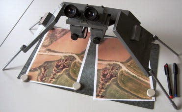
I remember learning how to detect a hidden nuclear missile silo camouflaged in the Russian landscape using stereoscopic glasses pointed at two LANDSAT images produced from orbiting satellites. Special imaging software was also being developed at the university to better filter and detect these patterns, and more, in remote sensing imagery.
But the kind of mapping I was most interested in was thematic mapping. I was mostly interested in computer graphics and animation, but I could also see the allure of bending cartography to serve creative means. For my senior project I converted a digital USGS topographic map of Santa Barbara into a 3D model so I could fly a camera over the terrain as a logo rose from behind the foothills. It was used as an intro animation for videos made for the newly formed National Center for Geographic Information and Analysis (NCGIA). This was, after all, the real focus of the geography department – and the U.S. government.
The influential chief geographer for the U.S. State Department from the 1920s through the 1940s, Samuel Whittemore Boggs, had settled on this cartographic dichotomy I was experiencing as a student. He surmised maps could be either rhetorical tools of delusion and propaganda (like fancy 3D animated video bumpers) or scientific instruments of knowledge and understanding (like Geographical Information Science). These two sides of a single coin were present 40-odd years later as I was studying geography at UCSB.
By the time I was studying cartography as an undergrad the Cold War was well embedded into the culture of all Americans, including institutions and universities. Some of my youngest memories as a kid were nuclear fallout drills at school. They weren’t all that different from tornado drills common to Iowa kids, but the films they showed us of the effects of nuclear blasts made me wish tornados were our only worry.
I also have memories of propaganda making its way into our school work as well. I remember math problems that compared missile lengthy between the U.S. and the U.S.S.R. – a nod to male anatomical one-upmanship.
Our culture was infused with geopolitical agendas and competitions pitting Americans against Soviets. I recall the ‘Miracle on Ice’ when the U.S. hockey team unexpectedly beat the U.S.S.R. in the 1980 Olympics. That was when the U-S-A chant was popularized. I was 15 and remember having a basketball game that day. The gym was electric with pride.
We all lived under constant fear and threat that the Soviet government could launch an intercontinental ballistic missile at any minute, so anything that felt like a victory was celebrated.
The fear was all well communicated and orchestrated using cartohypnotic techniques Boggs had warned of. This fear mongering wasn’t unique to the United States. University of Richmond professor Timothy Barney writes,
“An ominous arrow-filled 1970 map forecasts the logistics of a Greece and Turkey invasion, while another encircles Denmark and Northern Europe. The secret Warsaw Pact exercise ‘Seven Days Over the River Rhine’ from 1979 used cartography extensively to chart, complete with red mushroom clouds strewn about the continent, an all-too probable nuclear clash between Cold War powers.”1
The United States has a long history and practice of thematic political cartography dating back to the Paris Peace Conference in 1919. This inspired the formation of a thematic mapping division in the State Department. After World War II, in concert with the Department of Defense, Cold War propaganda elevated to a new level — including in cartography. It was cartohypnosis through government sponsored osmosis that created widespread prognosis of Soviet-American neurosis.
When Ronald Reagan became president in 1980, he had campaigned on increased military spending to ward off what he believed to be encroaching communism and military threat from the U.S.S.R. Reagan’s Secretary of Defense was his California friend, businessman, and politician Casper Weinberger, or ‘Cap’ as he was called. Weinberger shared the same fear Reagan did over evidence that cash-starved Russia was pouring much of their GDP into military spending.
To convince the American public that Reagan’s so-called ‘small government’ required ‘big spending’ on defense, he pulled a page from the 1918 State Department assembling a team of researchers, artists, illustrators, and cartographers to build his own ‘Inquiry’ into Soviet military weaponry and strategies. They produced a 100-page pamphlet called ‘Soviet Military Power’ out of the U.S. Defense Department that was intended to ‘alert’ the public to the ‘threat’ of the Soviet Union and the Soviet Armed Forces.
The first publications were distributed in 1981 across the country and were sold in Post Offices for $6.50 or $20 today. These were printed every year from 1981 to 1991 as what some government officials refer to as ‘public diplomacy’. However, scholars use ‘public diplomacy’ and ‘propaganda’ interchangeably because it’s often hard to discern which is which.
The fact is, these publications worked. They were a perfect compliment to Reagan’s public speeches that routinely referred to his Reagan Doctrine which was “to defy Soviet-supported aggression and secure rights which have been ours from birth.” This included funding overt and covert anti-communist resistance groups around the world – many of which illegally used acts of terror.
The Iran–Contra affair provided ample evidence of the malicious intents and actions behind Reagan’s Doctrine – funneling money from Iranian missile sales to fund militant guerilla fighters overthrowing the government in Nicaragua. Fourteen people in Reagan’s administration were indicted. Weinberger was indicted on five felony charges including accusations he lied to Congress and obstruction of investigation. Another four charges were brought against him but his cases were never tried. He was pardoned by then President George H. W. Bush, Reagan’s former Vice President.
Many of these sovereign nations the United States involved themselves in were seeking independence from reliance on foreign powers like the U.S. and the Soviet Union. However, because their forms of government often leaned toward social and communal inspired governments, Reagan assumed they’d fall under the control of the communist Soviet Union. It also meant Western corporations could lose out to state sponsored corporations.
The U.S. State Department had been attempting to spread Western economic and political propaganda around the world from at least the 1950s. President Truman’s Point Four Program (funded by the Ford and Rockefeller Foundations) and the Chicago Boys (programs involving neoliberal University of Chicago economists, including Milton Friedman) were efforts to spread right-wing libertarianism around the world. That included backing a military dictatorship in Chile.
REVERSING CARTOHYPNOSIS
By the 1980s these strategies helped instill fear in Americans that the Soviet Union could one day envelope the world. Decades of claims that communism spreads like a disease – Latin America today, Anglo America tomorrow – laid the groundwork in the 1980s for the ‘Soviet Military Power’ propaganda publications to have maximum impact. The fear in many is still there to this day and is heightened by Putin’s aggression via the Kremlin. Another example of an imperialist state department aggressively meddling in the business of a sovereign nation seeking their independence from an all-powerful overlord.
Author Tom Gervasi spent years in the late 80s researching the government’s claims made in these publications. He read the CIA’s annual reports to Congress, Military Posture Statements of the Joint Chiefs of Staff, sworn testimony from chiefs of the military services and Defense Department officials before the Armed Services and Appropriations Committees of Congress, as well as documents provided by NATO governments. He also consulted the International Institute for Strategic Studies in London, the Union of Concerned Scientists, the Federation of American Scientists, and the Stockholm International Peace Research Institute.
In 1988 he republished the 1987 issue of Weinberger’s ‘Soviet Military Power’ with annotations in the margins debunking many claims made by the U.S. State and Defense Departments. He also highlighted salient examples and techniques of propaganda, including cartohypnotic maps.
One shows the land mass connecting Europe with the former Soviet Union. The Soviet territory is covered with a blue blob overlaying its boundaries. Flowing south into Europe are massive arrows encroaching on Europe. The map gives the impression the U.S.S.R. not only has the opportunity to expand by land into all of Europe but that they also have the means to do so and a plan to do it.
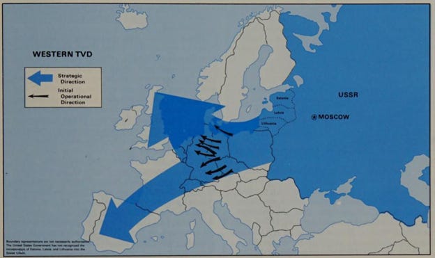
Gervasi comments in the margins asking us to
“Imagine opening a book and seeing the arrows going the other way, thrusting deep into the Soviet Union. The average American or West European reader would feel surprised and quite possibly indignant, finding it a complete misrepresentation of our intentions. That is how the average Soviet citizen would feel opening this book to this page. But this is powerful propaganda, immediately imprinting on our memory the vision of one possibility, without imprinting the reverse possibility, and so reinforcing allegations of Soviet intent made repeatedly, without any evidence to support them.”2
And in echoes of Boggs’ suggestion that cartohypnosis can be reversed, Gervasi reminds us that
“Indeed, images like the ones below are so deeply ingrained in the American psyche that if the propagandists can ever be silenced, it will take several decades of raising clear-sighted new generations to erase all our artificial fears and suspicions of the USSR.”3
Another map shows the entirety of the former U.S.S.R. in a simple outline with radiant cones stretched in every direction emanating from Moscow and other major cities. The title of the map is Ballistic Missile Early Warning, Target-Tracking, and Battle Management Radars. It suggests the U.S.S.R. had advanced radar systems ready to defend against attack.

Gervasi notes,
“This may give the impression that only the Soviets have such radars. A splendid map could be drawn of the U.S. radar system, stretching from Scotland to Hawaii, including the 12 large phased-array radars of our Ballistic Missile Early Warning System, the four large phased-array radars of our PAVE, PAWS system, the 75 radars of our DEW Line and North Warning System, our Perimeter Acquisition Radar Attack Characterization System, the three radars of our Navy’s Space Surveillance System, the 16 radars of our Air Force Spacetrack and other systems, and of course, our over-the-horizon backscatter radars. All of these are already fully operational, whereas the Soviet system shown here, as the text below acknowledges, will not be operational until the mid-1990s at the earliest.”4
Gervasi isn’t the only one to critique claims made in these publications. Even the conservative think-tank, The National Interest, debunks the ‘Pentagon’s exaggerations’ made in the these publications. In 2016 they took aim at what became Reagan and Weinberger’s pride and joy, the Strategic Defense Initiative – or as its was commonly referred to as, Star Wars. This was a space and ground-based laser program envisioned to obliterate threatening Soviet nuclear missiles. They write that Weinberger’s,
“Soviet Military Power made ominous predictions about Soviet lasers, lasers powerful enough to shoot down incoming nuclear missiles, or disable satellites in orbit…[the publication stated] ‘in the late 1980s, (the Soviet Union) could have prototype space-based laser weapons for use against satellites.’ It went on to imply that there were working anti-satellite lasers at [a] Soviet research complex…”5

In 1989 a group of Americans, including engineers and physicists, visited this research site. They concluded the Soviets could only produce a two-kilowatt laser beam. For comparison, experts claim 250 kilowatts are needed to destroy a weapon. It took until last year, 2021, for the U.S. to demonstrate a 300 kilowatt laser weapon. But means to consistently control this device keep it from being deployed.
The representative from Virginia, Jim Olin, a former electrical engineer at GE was on that tour in 1989 and said,
“It seems to me it pretty clearly is not a power laser and doesn’t represent any threat as a weapon.”6
In 1942, the librarian at the American Geographical Society, John Kirtland Wright, who is an authority on the history of geography, wrote on the power of maps:
“Like bombers and submarines, maps are indispensable instruments of war. In the light of the information they provide, momentous strategic decisions are being made today: ships and planes, men and munitions, are being moved. Maps help to form public opinion and build public morale. When the war is over, they will contribute to shaping the thought and action of those responsible for the reconstruction of a shattered world. Hence it is important in these times that the nature of the information they set forth should be well understood.”7
We live in a time when someone can go to their favorite search engine, type ‘map of Bering Straight’, copy and paste the image into an image editor, type in big red letters “RUSSIA” on one side of the maritime border and “USA” on the other, and voila…a map made to persuade public opinion. They can then feed it into the social media mass distribution machine and off it goes through a global network to be seen by more eyeballs than Casper Weinberger and Ronald Reagan could ever have imagined. If Boggs thought maps could be weaponized as hypnotic mind benders in the 1940s, imagine what he’d say now?
We’ve reached a point where making your own map has never been more accessible. And it’s only going to get easier. I’ve dwelled on the negative aspects of maps as propaganda, but I’m inspired by Boggs’ notion of reverse cartohypnosis. The threat of physical war has never been more real than it is today as the West continues to push an unpredictable dictator into a corner. A corner defined on territorial maps drawn in 1919 by American’s that defined boundaries between Russia and Ukraine. Maps that were made to persuade.
Putin is a man deluded by attachments to past maps that drew borders around a union of socialist republics. He has grown hateful of those who challenge that past, him, or his beliefs. His delusions are so grand that he may only be satisfied when he ‘wins’ or everyone else ‘looses’.
Like Biden and most presidents before him, he is both a victim of and an contributor to decades of cartohypnotism and through waring propaganda between two super powers seeking imperial domination.
With maps as weapons of war in an global battle for information superiority, I ask that we check our own delusions, aversions, and desires before becoming entranced by the seduction of a map. Arm our self-made mental radar and defense systems that warn us of intentions to exaggerate, placate, and sedate our vulnerability to bombs of persuasion. And should we decide to become a cartographer and make our own map one day, make sure we’re doing our best to reverse the effect of cartohypnosis.
Probable Axes of Attack of Warsaw Pact. Taken from Graham H. Turbiville, "Invasion in Europe--A Scenario," Army, November 1976, p. 19.
Soviet Military Power* *The Pentagon’s Propaganda Document, Annotated and Corrected. Tom Gervasi. 1988.
Ibid.
Ibid.
How the Pentagon Exaggerated Russia’s Cold War Super Weapons. The National Interest. Kyle Mizokami. 2016.
Ibid.
The History of Cartography, Volume 6: Cartography in the Twentieth Century.


