


Hello Interactors,
This week we pick up where we left off with Thomas Jefferson. Jefferson had appointed Thomas Hutchins to be Geographer of the United States in 1781. In 1784 Jefferson was preparing for expansion west and was combing over Hutchins’ descriptions of what lie west of his beloved Virginia. Jefferson was dubious of Hutchins’ mapping facts and took it up with him in a personal correspondence. What follows is the unfolding of a cartography project of Roman scale. And the birth of an empire.
As interactors, you’re special individuals self-selected to be a part of an evolutionary journey. You’re also members of an attentive community so I welcome your participation.
Please leave your comments below or feel free to email me directly.
Now let’s go…

ON TURTLE ISLAND
Thomas Jefferson was born with a passion for measuring the world. His father, Peter Jefferson, was a surveyor, naturalist, cartographer, and colonial settler. He instilled in his son a love and interest in the culture and languages the Indigenous people. Later in life, Thomas Jefferson even partnered with another Indigenous admirer and fellow colonizer I mentioned back in February, Roger Williams. They collaborated on documenting the nuances of local native languages. Jefferson compiled twenty years of notes on Indigenous dialects and culture that travelled with him to New York City when he became president. Upon returning to Monticello the boatmen responsible for transporting his belongings ripped opened a box containing the precious papers in search of valuables to be stolen. When all they saw were piles of paper, they tossed them overboard. Decades of research and knowledge lost. As a young man, Jefferson spent time with Indigenous people – and so did his father. In a letter to John Adams, Jefferson writes,
“Concerning Indians . . . in the early part of my life, I was very familiar, and acquired impressions of attachment and commiseration for them which have never been obliterated. Before the Revolution, they were in the habit of coming often and in great numbers to the seat of government where I was very much with them. I knew much the great Ontassete, the warrior and orator of the Cherokees; he was always the guest of my father, on his journey's to and from Williamsburg.”1
Even as Jefferson was scheming to carve up the land his forefathers had invaded into a cartesian grid, he held natives in high regard, writing in 1785,
“I am safe in affirming that the proofs of genius given by the Indians place them on a level with the whites. . . . I have seen some thousands myself, and conversed much with them. . . . I believe the Indian to be in body and mind equal to the white man.”
Thomas envisioned an interracial “Continental America”. Later, in 1802, he said to a group of native Americans, "Your blood will mix with ours, and will spread, with ours, over this great island." The word ‘island’ is most likely in reference to ‘Turtle Island’ which is rooted in the Native North American creation story, including the Haudenosaunee – a confederacy of six nations in the Northeast. This ancient tale tells how the ‘Great Sprit’ (a term Jefferson commonly used in place of the word ‘God’) created the land of America and its people – complex people capable of both good and evil. As Jefferson was toiling over Hutchins’ maps and words in 1784, looking west at the silhouetted Blue Ridge Mountains of Virginia, he was about to embark on an endeavor that history can now regard as both good and evil.
JEFFERSON MISCALCULATES
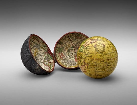
Jefferson loved contemplating the universe and fell in love with astronomy in college in 1760. The study of the stars gave him an appreciation for the universe Isaac Newton had revealed a century before. On his transatlantic trips to and from England and France, he’d be on deck exacting the stars dotting the dark sky and calculating meridians as the boat curved along the earth’s surface. He collected maps, globes, and sextants and obsessed over the global coordinate system. He wasn’t alone. This was a time when a consistent calculation of longitude remained elusive and there was a £20,000 prize for a solution. Newton believed the solution would come from astronomy, but woodworker and clockmaker, John Harrison, invented a mechanical marine chronometer and won the prize in 1773.
So it should come as no surprise that Jefferson was able to scrutinize the maps his newly appointed chief geographer, Thomas Hutchins, had published of the territories west of Virginia. Hutchins had been in this role just three years when Jefferson wrote to him with this inquiry in 1784:
Sir
I have been recurring to your pamphlet (which I borrowed for that purpose) for the times at which the inundations begin and end in the Missouri, Missisipi, Illinois, Ohio, Wabache, but I do not find it mentioned there. Will you be so kind as to give me as accurate an account of these times as you can? Does the Tanissee overflow periodically? I suppose not. Will you give me leave to correct an error in your pamphlet page 13. where you say that the country extending from Fort Pitt to the Missisipi and on both sides watered by the Ohio and it’s branches contains at least a million of square miles. I think the Ohio in all it’s parts and branches cannot water more than the fourth of that. Count the degrees in your map into which it pushes it’s branches. You will find them not quite 80, but suppose them made 80 by the branch of the Tanissee which heads in S. Carola. A degree in the middle of this space would contain about 3000, or 3100 square miles and of course 80 would contain about 250,000. I think the whole United states reduced to a square would not be more than one of 900 miles each way and of course that the whole U.S. do not contain a million of square miles. Excuse my freedom. I think this an error in your pamphlet and would wish to know from you whether I see it wrong. I am with much esteem Sir
Your most obedt. servt
Th: Jefferson
The pamphlet Jefferson is referring to is Hutchins 1778 publication, Topographical Description of Virginia, Pennsylvania, Maryland, and North Carolina. Hardly a pamphlet as we think of them today, it’s over 100 pages of mostly textual descriptions of the land he had explored as far west as the Mississippi River. The majority of which highlighted the agriculture, climate, and land features suitable for settling. As a plantation owner who believed farming was the future of America, it makes sense Jefferson took such interest in the ratio of water to land in Hutchins’ work. It was all part of his grand vision of a mass agrarian expansion west. This is why he wanted Hutchins to lead efforts to survey, measure, and carve it up into a precise and quantifiable grid. Just as the latitude and longitude lines carve up the globe as he bobbed his way across the Atlantic.

But Jefferson’s estimation of Turtle Island’s expanse was way off. The whole United States reduced to a square, as Jefferson posited, would end up being nearly four times larger than he imagined. Jefferson didn’t believe that imaginary rectangle could be larger than a million square miles, but it turns out to be nearly four million miles square. Since he’d never really travelled west of the Blue Ridge Mountains, it’s easy to see where it would be hard to imagine. It’s hard to imagine four million square miles even when seen from a satellite image. What Jefferson was trying to rectify, was just how much land to quantify, upon which taxes his country could rely.
HUMAN RIGHTS. STATE FIGHTS.
Jefferson was acting out what had already been done in Europe in the late 1600s and early 1700s. Rulers pushed for more centralized power and control and cartography played a staring role. The Enlightenment led to what some describe as ‘Enlightened Absolutism’.
Two elements emerge under this interpretation of the Enlightenment:
An explosion of discovery and invention that led to cultural and societal advancement.
A recognition of needed state resources, power, and control for the purpose of war.
It fell on cartography to map the acquisition of land through the drawing of lines for the exercise of power. Modernization during the enlightenment included demonstrating governance through systematic documenting and registering of land. Jefferson, a worshipper of the Enlightenment, was acting out the ‘enlightened’ European practice of nation building, cadastral mapping, and growing an army.
The revolutionary war had left the new formed United States of America strapped for cash. Like their European contemporaries, they went about collecting funds through subdividing the land to excise tax. When Jefferson wrote to Hutchins in January of 1784 with his questions, he likely was in the process of preparing the Land Ordinance of 1784. This document called for the creation of states west of the Appalachian mountains, north of the Ohio River, and east of the Mississippi River. The ordinance included these five articles:
The new states shall remain forever a part of the United States of America.
They shall bear the same relation to the confederation as the original states.
They shall pay their apportionment of the federal debts.
They shall in their governments uphold republican forms.
After the year 1800 there shall be neither slavery nor involuntary servitude in any of them.
This ordinance was put to committee in April of 1784, but with one glaring omission – Article 5. Abolishing slavery lost by a single vote. Virginia representative James Monroe was absent from voting, at home sick in bed. Monroe, like other slave owning Virginians including Jefferson and James Madison, were routinely conflicted over slavery. They struggled with two competing ideals, upholding the enlightened values of human rights they ensconced in the constitution, and holding together this loose collection of newly formed states for fear of civil war over the issue of slavery. Another example of tension riddled compromise came 16 years later when the absent voter, Monroe, was then President of the United States. He signed the Missouri Compromise in 1820 which admitted Missouri as a slave state while abolishing slavery in states to the north. To this day, our elected leaders continue to waffle on the rights of all humans as imagined by Jefferson. After the loss of Article 5, Jefferson wrote,
"The voice of a single individual would have prevented this abominable crime; heaven will not always be silent; the friends to the rights of human nature will in the end prevail."
There were also conflicts over just how these states should be carved up. Jefferson had a clear vision of uniform divisions for the purpose of expansion, taxation, and farming. But corporations and private land speculators had other ideas. They had already been grabbing up land and selling it to settlers for a profit. They also had an ally in the government – Alexander Hamilton. This pitted Jefferson against Hamilton in how to measure and divide the newly acquired land.
Former surveyor and cadastral mapping historian, C. Albert White, writes, the Jefferson group included advocates:
“of [the] sale [of land] to individual settlers in small parcels. The small farmers, frontiers men, and merchants argued that an essential part of a democracy was the right to own property. They could not afford to buy land in large tracts, and if it were sold in huge blocks to wealthy men, the small man would be squeezed out or forced to pay high prices and interest.”
Meanwhile, the Hamilton group was:
“generally made up of wealthy southern aristocrats and plantation owners, did not think the democracy advocates were capable of settling the land intelligently or capable of handling land ownership. The conservatives were in favor of large grants at low prices to companies or wealthy men who would then handle the business of settlement, such as surveying and patenting.”
This was around the time Hamilton was establishing the Bank of New York and he thought Jefferson’s rational approach to subdividing the land would take too long. He favored the rough and tumble approach called ‘metes and bounds’ which is a method that had established the irregular boundaries of the existing colonies and states. It was also a system that had already clogged the courts in land disputes. But Hamilton argued,
“It had not been the general governmental policy in the colonies to sell land as a source of revenue prior to the war. The people were familiar with the free settlement system and would occupy and hold the territory faster if allowed free location.”
AN ORDINANCE ORDAINED
Jefferson, ever the cartographer’s son, knew what he was doing and pushed ahead with his plan. The expansion west would be divided into a grid. And in echoes of the Roman land plots called ‘centuries’ mentioned in last week’s post, Jefferson would follow by naming them ‘hundreds’. As C. Albert White documents:
“In 1784, a committee headed by Jefferson drafted an ordinance which called for prior survey of tracts ten geographical miles square, which were called hundreds; they would be subdivided into lots one mile square. The lines would run due north and south, east and west and settlement would be by hundreds or by lots.”
After months of debate, the tract size was reduced from ten to seven mile-squares with 49 township lots. One square would be allocated for a school, another for a church, and four would be reserved for Congress to assign at a later date. One-third of any precious minerals found would also be granted to the government. The township squares were to be sold at auction for $1 per acre.
This plan drew further objections and the size was reduced once again to six miles square. The intent was to minimize land barons from buying large tracts on speculation. There was also fear that townships spread too far apart would leave them overly vulnerable to attacks by angry Indigenous nations. On May 20, the Land Ordinance of 1785 was passed.
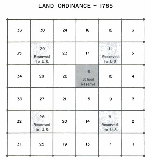
"Be it ordained by the United States in Congress assembled, that the territory ceded by individual states to the United States, which had been purchased of the Indian inhabitants, shall be disposed of in the following manner:
A surveyor from each state shall be appointed by Congress or a committee of the states, who shall take an oath for the faithful discharge of his duty, before the geographer of the United States, who is hereby empowered and directed to administer the same; and the like oath shall be administered to each chain carrier, by the surveyor under whom he acts.”2
The chief surveyor and geographer of the United States under whom they would act was Thomas Hutchins. He was granted a team consisting of one surveyor from each of the 13 States. But only eight showed up to work. Their first task was to map a section of land west of the Ohio River bordering West Virginia known as the Seven Ranges. This was the beginning of the United States Public Land Surveying System, known today as the Bureau of Land Management.

Hutchins and his crew began work September of 1785 on the north bank of the Ohio River. But it only lasted a week. On October 8th word came of Indigenous unrest due west of their site near land occupied by the Tuscarawas. Hutchins and his crew had only surveyed four miles. A disappointing start to a monumental task. And their troubles had only just begun.
Exemplar of Liberty: Native America and the Evolution of Democracy. Donald A. Grinde, Jr., Rupert Costo Professor of American Indian History, University of California at Riverside., Bruce E. Johansen, Associate Professor of Communication. University of Nebraska at Omaha. 1990.
A History of the Rectangular Survey System. C. Albert White. Jan 1983. U.S. Department of the Interior, Bureau of Land Management.


Share this post