

Hello Interactors,
Chicago was bursting at the seams at the turn of the century. People were stressed, companies were panicking, and something had to be done. They needed a plan; a map of a 20th century city. They needed someone to draw a picture, ease their minds, and persuade Chicago’s industrial elite.
As interactors, you’re special individuals self-selected to be a part of an evolutionary journey. You’re also members of an attentive community so I welcome your participation.
Please leave your comments below or email me directly.
Now let’s go…

THE POWER OF THE PEN
It wasn’t going to end well. The mechanical engineering class was split in their opinions over elements of a design for a handle bar bracket they were designing. It was getting tense. There was yelling, pointing, and gesturing among the aggressive ones while distracted, despondent doodlers were dawdling in the margins. The instructor, clearly rattled, was vainly refereeing the melee. Then, from the back of the class, came a calm but firm interjection. “Can I make a suggestion?”, a man’s voice said. The class whirled around in their seats. There was another professor seated in the back, but who was he?
Last week we left Chicago at the turn of the century. The flood of immigrants from the 1830s to 1900 had led to exponential population growth. There were nearly 4,000 people living in Chicago in the 1830s and over two million by 1900. It made a lot of people rich, but left many more poor. It was also causing congestion, pollution, and, yes, disillusion. Chicago was not becoming what the city’s elite had imagined. Those who could, escaped to the suburbs proffered. Those who couldn’t, scraped by on whatever was offered.
But everyone was frustrated, confused, anxious, and scared. Infamous Chicago organized crime had been building for decades with crooks named Michael ”Hinkey Dink” Kenna, George “Bugs” Moran, and the “Bloody Gennas” – six Sicilian brothers “Bloody” Angelo, Mike “The Devil”, and Pat, Sam, Jim, and Tony – “The Gentlemen.” Railroads were stringing rail lines into the city, boats were crowding the harbors, and the glimmer of automobiles was on the horizon. Companies were booming and competing for rights to increasingly limited public land. The government did their best to mediate and keep the town running, but it was getting heated. Then somebody in the periphery was asked to make a suggestion.
As that engineering class was staring down the mysterious man in the back, he continued, “I’m not a mechanical engineer so I’m having trouble understanding what you’re talking about. Would someone kindly draw a picture of this bracket on the whiteboard so I can see what it is you’re arguing about?”
All of the students look at each other and then one sheepishly admitted what they were all thinking, “I don’t really know how to draw.” Eventually somebody was delegated to draw a rough sketch of the part. They then circled and labeled the elements they were discussing. The room erupted again in debate. “That’s not what we’re talking about!”, said a boisterous one as they charged the whiteboard. They grabbed another marker and circled and labeled another element. “What are you talking about?”, said another as they leapt from their seat for the board. Soon, all of the students were gathered around the whiteboard, pens in hand, visually negotiating a resolution. With the power of the pen, and the emergence of an image, comes the persuasion of people. To visualize is to compromise.
THE WINDY WHITE CITY
Seven years before the 20th century arrived, Chicago hosted the 1892 World’s Fair: Columbian Exposition. Otherwise known as the Chicago World’s Fair. But most people ended up calling it ‘White City’ due to the white neoclassical architecture it featured, but in today’s social context it was ‘White’ for other reasons. For one, it was celebrating the 400 year anniversary of Christopher Columbus “discovering” America. For another, the organizing committee refused to appoint any Black or African-American members. There were Black and African-American exhibits accepted as a consolation, but even though these Americans comprised one tenth of the population at the time, it seemed the organizing committee would rather not hear from them.

Ida B. Wells, a Chicago resident at the time, Frederick Douglass, and Irvine Garland Penn didn’t sit idly by. They produced a pamphlet entitled, The Reason Why: The Colored American is not in the World's Columbian Exposition. It was printed in English, French, and German. The preface reads like this:
“TO THE SEEKER AFTER TRUTH:
Columbia has bidden the civilized world to join with her in celebrating the four-hundredth anniversary of the discovery of America, and the invitation has been accepted. At Jackson Park are displayed exhibits of her natural resources, and her progress in the arts and sciences, but that which would best illustrate her moral grandeur has been ignored.
The exhibit of the progress made by a race in 25 years of freedom as against 250 years of slavery, would have been the greatest tribute to the greatness and progressiveness of American institutions which could have been shown the world. The colored people of this great Republic number eight millions – more than one-tenth the whole population of the United States. They were among the earliest settlers of this continent, landing at Jamestown, Virginia in 1619 in a slave ship, before the Puritans, who landed at Plymouth in 1620. They have contributed a large share to American prosperity and civilization. The labor of one-half of this country has always been, and is still being done by them. The first credit this country had in its commerce with foreign nations was created by productions resulting from their labor. The wealth created by their industry has afforded to the white people of this country the leisure essential to their great progress in education, art, science, industry and invention.
Those visitors to the World's Columbian Exposition who know these facts, especially foreigners will naturally ask: Why are not the colored people, who constitute so large an element of the American population, and who have contributed so large a share to American greatness, more visibly present and better represented in this World's Exposition? Why are they not taking part in this glorious celebration of the four-hundredth anniversary of the discovery of their country? Are they so dull and stupid as to feel no interest in this great event? It is to answer these questions and supply as far as possible our lack of representation at the Exposition that the Afro-American has published this volume.”1

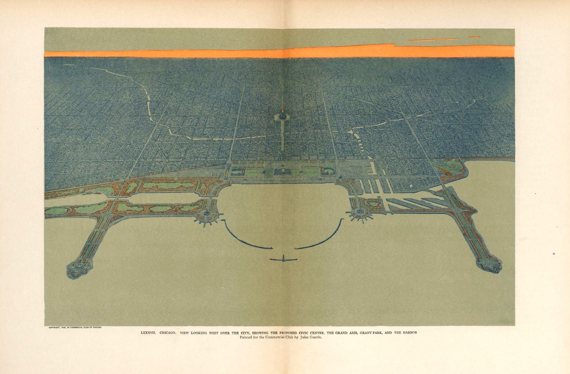
The lead architect of the neoclassical “White City” was Daniel Burnham. He was lauded by the White organizing committee for capturing the essence of the American exceptionalism they intended the fair to evangelize. It was the largest exposition to date and drew over 750,000 people on its opening day. So in 1906 when Chicago was fuming in its own waste, clogged with congestion, and stuck with an unclear path forward, a group of industrialists, called the Commercial Club of Chicago (which is still around today), called Burnham to the front of the room to draw them a picture. The project was called the Burnham Plan.

WAR OF WORDS AND WATERCOLORS
Burnham had already sketched some ideas of how to improve the city’s waterfront after the World’s Fair had concluded. He also helped other cities like Washington D.C., Cleveland, and San Francisco with their own plans. Some regard him as the father of American city planning. Burnham signed on a partner, Edward H. Bennett who ended up doing much of the coordination. But they also hired a prominent muralist and watercolorist, Jules Guérin. Burnham knew his ideas, along with the ideas of the Commercial Club members, would take some selling to the public, other prominent businessmen, and the city government. He needed more than a sketch, a plan, or even a map. He needed people to be both inspired and consoled. But also persuaded.
#/media/File:BurnhamPlanOfChicago-CivicCenterPlaza-JulesGuerin.jpg)
What led to the contention and confusion in that mechanical engineering class wasn’t just differing opinions. That’s what came out in their actions, but what compelled these people to react as they did was more likely anxiety, frustration, confusion, and maybe even fear of being wrong. It’s that same feeling we have when we’re disoriented or lost. There’s a unique image in our head, if we can access it, that will orient us when we’re lost. Every student in that classroom had their own individual image of that bracket in their head. They just needed to access it.
But manifesting that image through words can be inadequate and frustrating. Words only get us so far. That’s why images are worth a thousand words. So in our struggle to reason with that feeling inside us we can sometimes lash out, point fingers, blame the environment — and sometimes each other. What an image provides, be it a drawing or a map, is clarity. Certainty. It makes the invisible visible, the impossible possible, and persuadable persuaded. And, yes, it can also be consoling.
Jules Guérin was a good choice on the part of Burnham. His serene cityscape watercolors not only represented the rational, orderly, and systematic plan of Burnham, Bennett, and others, but they made Chicago look calm, peaceful, and serene. Maybe even egalitarian. These artistic maps drew inspiration from Europe — especially the Beaux Arts movement of Paris. Georges Eugène Haussmann had executed a similar city plan of Paris fifty years earlier. It was good timing in the lead up to their 1889 World’s Fair and the construction of the Eifel Tower in 1887. Paris was a medieval mess until Napoléon III hired Haussmann to redesign and renovate the city. His work is now synonymous with the allure of Paris.
Guérin ended up painting over 150 images that Burnham used for presentations or to be hung in the halls of buildings housing influential commercial and governmental decision makers. His work wasn’t only pleasant to look at, but featured elements that appealed to a wide variety of constituencies. Some paintings included pastoral forests, farms, and open space contrasted with railroad tracks bordering or dividing the natural landscape. Many included high contrast lightly rendered rivers and lakes that featured both boating for pleasure and commerce. There was something for everyone.

But one of the most distinctive elements, is the aerial bird’s eye view. This unique perspective allowed the paintings to be seen as traditional works of art, but also allowed Burnham to sell his vision of an orderly, well structured, architectonic city. Just like the ones in Europe. This style of painting, mapping, and planning of cities came to be known as the City Beautiful movement of urban design and planning that spread across the country.
Burnham was a master at leveraging the power of these illusory, artistic, and fanciful maps to persuade. But he wasn’t doing it alone. He had the full backing of the Commercial Club who came with their own ideas. But they weren’t alone either. There were competing visions for the city. One contentious element was the refactoring of Michigan Avenue. Burnham’s plan called for both widening and elevating a portion of the street and connecting the two roads with a double decker bridge. Another group called the Michigan Avenue Improvement Association had a simpler idea. They wanted to widen the street, but keep it at one level connected by a single level bridge. Both groups spent two years drawing pictures, making pamphlets, and arguing.
NOTHING NEW SINCE THE GREEKS
Just like those students all standing around the whiteboard, with pen in hand, they were debating, negotiating, and persuading with pictures. It’s what that guy in the back of class was looking for. The mysterious observer was the head of the Design Department at Carnegie-Mellon at the time, Dick Buchanan. He’s now at Case Western Reserve. He was curious how the engineering department was teaching their students, so he asked to sit in on a class. Drawing is a part of the foundational curriculum in design schools, but he learned maybe that wasn’t the case in engineering. Mr. Buchanan also knows the power of persuasion. He studied rhetoric in college and understands the power of carefully crafted words and images to persuade.
The Burnham plan wasn’t the first to take the approach of top-down patriarchal style city planning. Idealized fantasy cities dot the history of western civilization. In Ancient times, the Greek city of Miletus grew from a planned city map dating back to 450 BCE. Milesian settlers used plans like these throughout present day Turkey. Their grid formations became the basis for the gridded Roman cities that I mentioned in my first post of this spring series on Roman cadastral surveying and mapping. These methods continue to be the dominant form of urban planning today.
The grid went dormant in mapping and city structure when the Roman empire fell and throughout medieval times. Just like large scale cadastral mapping, it didn’t reappear until the Renaissance. This time the cartesian arrangement included elements of protection to guard against organized military attacks on monarchies. They were optimized for the interaction of people and place and monetary exchange within their borders and thus took on radial and symmetrical arrangements. Architects and designers like Leonardo da Vinci reached back to 80 BCE and the books Vitruvius wrote on structured, practical, architecture to draw these schemes.
Another influential, though less famous, craftsman, artist, architect, and writer of the Renaissance was a man named Filarete. He wrote a highly influential book on architecture in 1464 called Libro architettonico or “Architectonic book.” Even da Vinci was pulling ideas from his work.
His book featured a fictional storyline that included an idealize city called Sforzinda. Including a star shaped diagram of the city plan. Humanism was at the center of Renaissance philosophy so art and design often echoed the proportion and function of humans. This trope is also a nod to Vitruvius and his Vitruvian Man that was popularized by Leonardo da Vinci’s famous 1490 illustration of the man with outstretch arms.
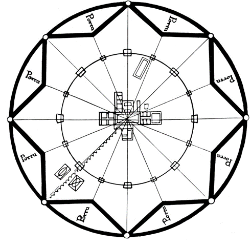
Newcastle University Urban Design Professor, Ali Madanipour writes,
“The desired order was to be achieved by a single design for an entire city, anticipating Machiavelli and Descartes who also looked for a single source of order, which politically became manifest in absolute monarchies.”2
The idealized city Burnham had devised 500 years later drew from these ideas. It had been occurring around Europe throughout the Renaissance and into the Industrial Age. The orderly, industrialized, and mechanized designs of factories, tools, and products were now being applied to cities. Just as monarchies in Europe looked to artists, designers, and craftsman to bring order to the design of their cities and societies, so were industrialists looking to Burnham and others to bring order to Chicago and its people. A plan that was modelled from ancient European history, and the recent history of the Chicago World’s Fair and American exceptionalism.
For both the fair and the Burnham plan, it was White men who held dominant roles in public politics and private enterprise that were in charge. They wielded a moral authority that leaned on America’s founding claims of ‘Manifest Destiny’. A moral code summarized in six words, “Is this yours? It’s mine now.” These men also had privileged social status and felt entitled to their benefits, wealth, and rewards even at the detriment of the lives of Black Americans, Indigenous nations, disadvantaged immigrants, and poor White Americans.
Fearful that their privilege, status, or wealth may be challenged by growing populations of people different from them, they turned to power, order, and domination. They sought control over the situation. All they needed was someone to draw a picture. A map. A drawing. Something that would ease their mind. So Burnham stood at the head of the class, grabbed some chalk, and before he knew it he had Chicago’s most powerful men drawing pictures of their idealized future.
The Reason Why the Colored American Is Not in the World's Columbian Exposition. Manuscript/Mixed Material. https://www.loc.gov/item/mfd.25023/
Madanipour A. (2015) Filarete. In: Sgarbi M. (eds) Encyclopedia of Renaissance Philosophy. Springer, Cham.


