


Hello Interactors,
Welcome to the third in a series on the role surveying and cartography played in the establishment of the United States. Today we continue further west into Ohio in the lead up to the 1800s. The U.S. government needed money to fulfill their dreams of being a global superpower. And it all hinged on Jefferson’s plan to extract money from neatly surveyed squares of land occupied by sovereign Indigenous nations who had been here for thousands of years. They were not going to give easily and they never will.
As interactors, you’re special individuals self-selected to be a part of an evolutionary journey. You’re also members of an attentive community so I welcome your participation.
Please leave your comments below or email me directly.
Now let’s go…

THE SEVEN RANGES RAGE ON
“Regulating the grants of land appropriated for Military Services, and for the Society of the Brethren, for propagating the Gospel among the Heathen.”
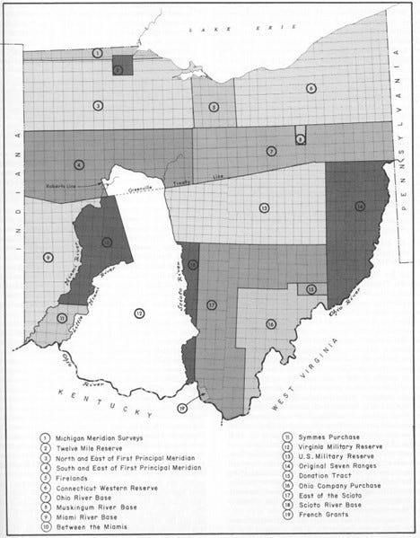
This is the title of the Land Act of 1796. It was enacted on June 1 of that year, nearly a decade after the United States’ chief Geographer, surveyor, and mapmaker, Thomas Hutchins, had died after surveying the Seven Ranges just west of the Ohio River. The gridding and partitioning of land further west into Ohio continued to progress. The decade leading up to the Land Act was filled with increased Indigenous resistance, botched surveys by scandalous land speculators, and an eager and anxious government who needed money for their military and land from the ‘heathens’.
The Seven Ranges did not produce the kind of revenue Congress had anticipated. It was risky business for individual settlers to forge into territories of unhappy native occupants who had no allegiance to Thomas Jefferson’s cartesian adherence. The government was offering land to colonizers for cheap, at one dollar per acre, but you risked your life squatting on land unprotected from Indigenous land and water protectors. So many colonizers just waited for land speculators to buy the land so they could buy it at a discounted price – plus interest. Settlers also had to pay for the survey that proved to the government and their neighbors that it was ‘their’ land. This meant the surveys mapping their plats and townships were sloppily produced or not made at all.
Sometimes land companies would provide squatters security and protection from violence they may encounter. But it was rare. Tribal nations in this area were accustom to dealing with invaders. They had a history of negotiating with both the English and the French prior to the Revolutionary War. The French needed Indigenous allies given they were outnumbered by the British colonizers. At the beginning of the French and Indian War, in 1754, there were nearly two million in the British colonies and only 60,000 among the French colonies. The Indigenous nations would sometimes pit the English and French against each other in hopes of securing and maintaining land for themselves. After the Revolutionary War, there was a third country vying for Indigenous land, the United States. The fight for land with this nation by Indigenous nations continues to this day.
You can read more about the Land Back movement and it’s importance to future healthy interactions of people and place here.
A FOOLING OF HARD KNOX
Recall from a previous post that it was the end of the French and Indian War, in 1763, that Thomas Hutchins was working for the British army. He was surveying and securing land along the Ohio River for the British and allied Indigenous nations. Twenty one years later, in 1781, Hutchins became the chief Geographer for the United States helping Jefferson with the details of the Land Ordinance of 1784. The original plan for the dicing up of American land. And now, after platting the Seven Ranges and Hutchins’ passing in 1789, the Ohio surveying experiment had been overrun by land speculators, squatting settlers, and angered Native nations. But these fierce, proud, intelligent Indigenous nations were once again ready to negotiate alliances with the global super-powers. Including upstarts like the United States.
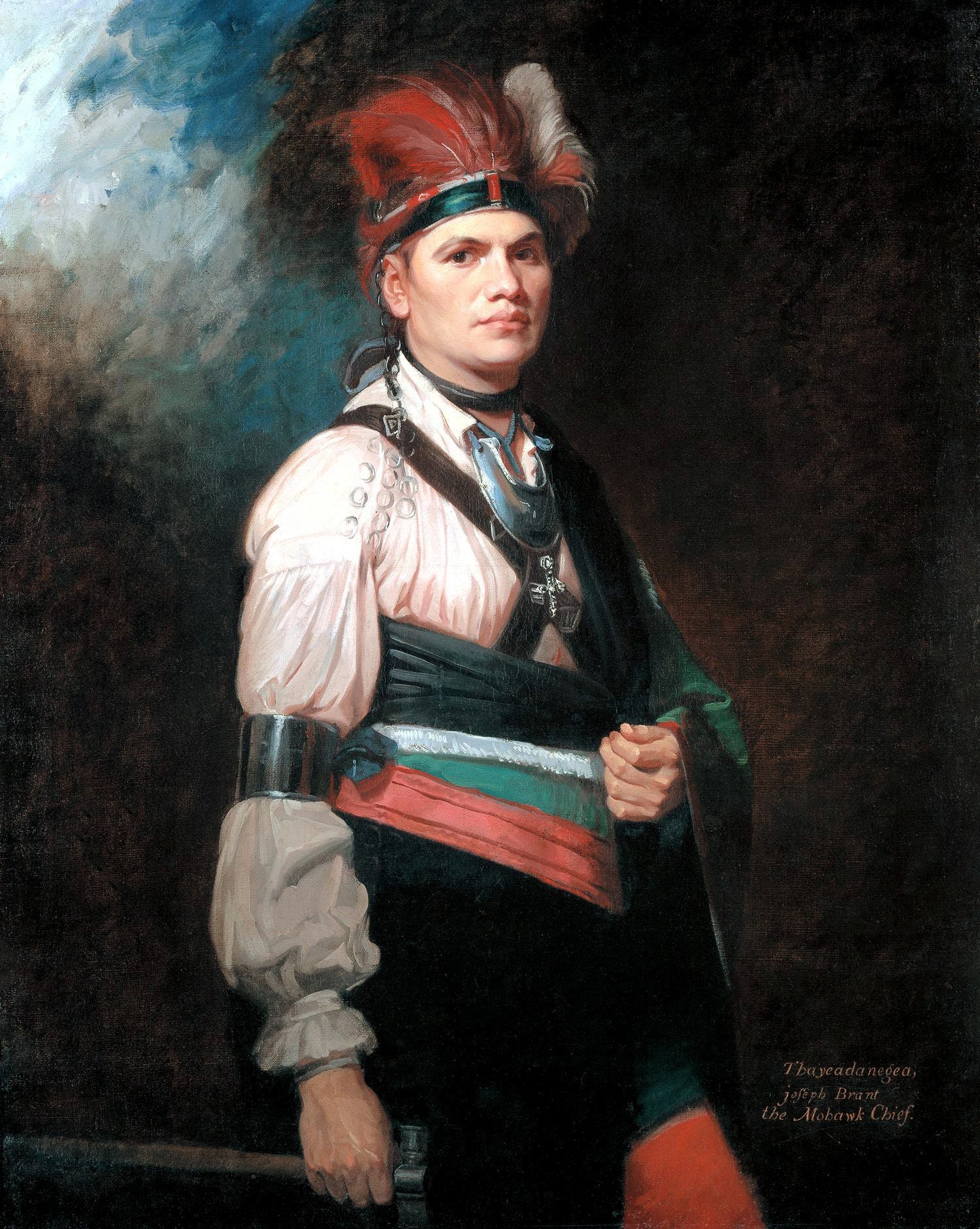
By this time political and military negotiations were led by a White Mohawk leader, Joseph Brant. Brant was born in Ohio to parents that had been raised with the Iroquois in the New York area. He grew up in a multi-cultural world among settling French, Irish, German, English, and his Mohawk people. He was able to speak all the dialects of the Haudenosaunee Confederacy and was educated in 1761 at what was to become Dartmouth College. He rose into leadership positions both within his Mohawk tribe and the British Army and was feared by the United States due to his ability to negotiate with the British and the French. He was also a skilled warrior unafraid to fight for the rights of the people he and his parents grew up with. A fight that had already begun. The Northwest American War, also known as the Ohio War, began the year Hutchins’ set out to survey the Seven Ranges in 1785.
The allied Indigenous nations were about to do battle with Washington’s newly appointed Secretary of War, Henry Knox. The United States had secured their own Indigenous allies from the south, the Chickasaw and Choctaw. But the United States military was outnumbered. Knox had to recruit Kentucky squatters who were untrained but motivated by the prospect of land and bounty from the brown scalps of Indigenous men, women, and children. The United States was also poor. Proceeds from the land Hutchins had surveyed west of the Ohio River were barely trickling in. But Knox was determined, telling his Commander stationed at a fort in what is now Cincinnati,
“…extending a defensive and efficient protection to so extensive a frontier, against solitary, or small parties of enterprising savages, seems altogether impossible. No other remedy remains, but to extirpate, utterly, if possible, the said Banditti (bandits).”1
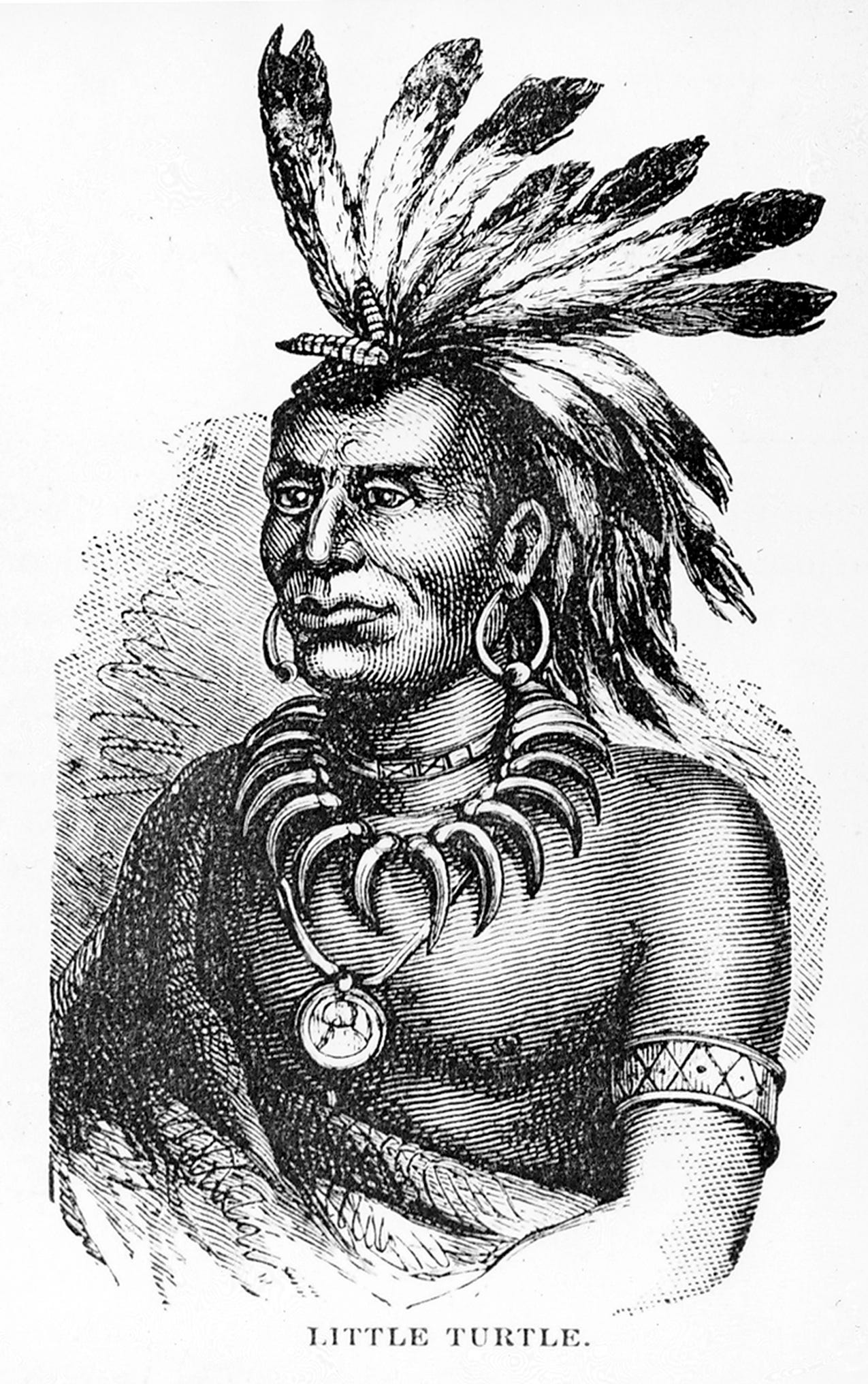
The Miamis and Shawnees were able to fool Knox’s first attempts to destroy their villages. They would desert their grounds and then ambush the troops after watching them set fire to their homes. Defeated, Knox went on to recruit 500 more from Kentucky and issued stronger demands to his commanders. They destroyed the Miami’s largest villages and took 40 women and children hostage. They then sent word to villages up the Wabash river to surrender or risk being exterminated. Knox wrote,
“Your warriors will be slaughtered, your towns and villages ransacked and destroyed, your wives and children carried into captivity, and you may be assured that those who escape the fury of our mighty chiefs shall find no resting place on this side of the great lakes.”
ENTER “MAD ANTHONY”
Back in New York, Secretary of Treasury, Alexander Hamilton needed a plan. The country continued to bleed money and he needed more land in Ohio to be surveyed and gridded into a ledger so he could balance the governments finances. On July 20, 1790 he established the General Land Office which included the position of Surveyor General. Hamilton determined 100 acres and upward were to be sold to land companies for 30 cents per acre. The land could be paid for in gold, silver, or public securities – many of which were war credits earned during the revolutionary war. Land could also be sold with a two year credit plus six percent interest. Townships were 10 miles square and the surveys had to be paid for by the land companies or their land-seeking colonial settlers.
This was attractive to would-be land owners, many of whom migrated from Europe where they had no hope of ever owning a piece of property. This was a dream come true, if not for the nightmare of violence occurring throughout Ohio. George Washington was recruiting, and Indigenous warriors were killing, mercenaries from Kentucky and Tennessee at a rate of four for every one trained U.S. soldier. But he knew this was the price you pay to become a global power like England, France, or Spain. He knew he needed their land to raise the money necessary to build a stronger army, but no matter the size of troops he was sending in to battle, they were losing terribly. The Indigenous people of Ohio were not going to give in. They never have and they never will.
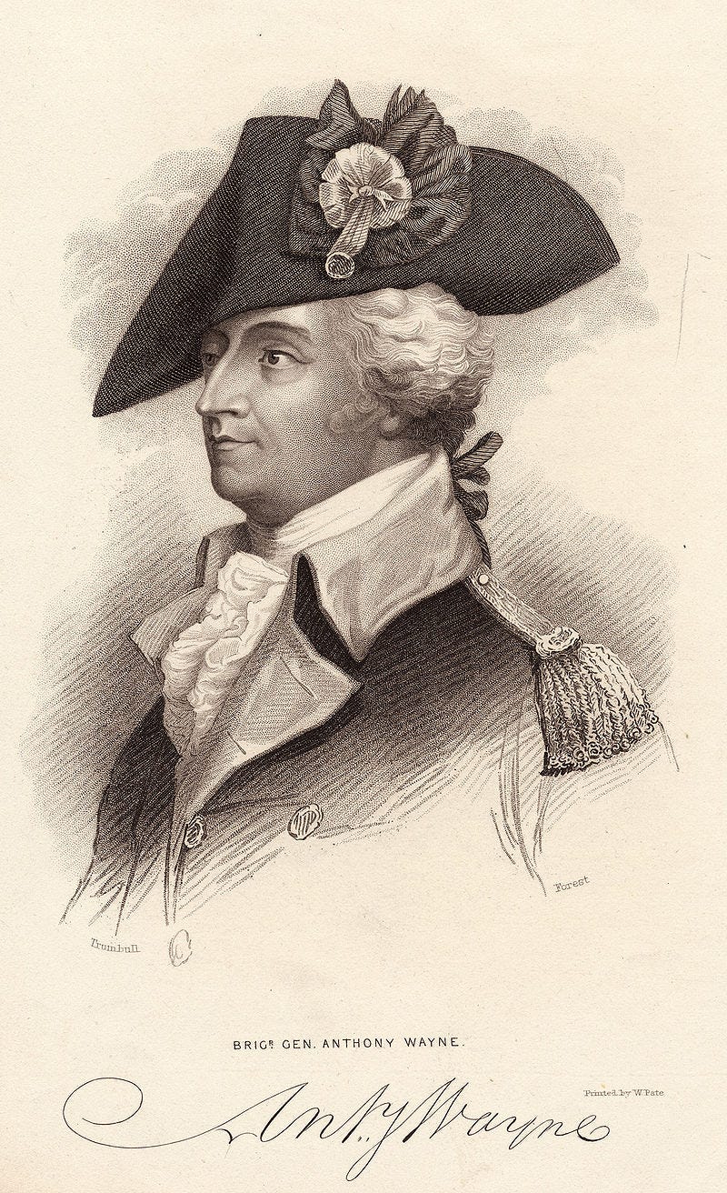
Washington needed a new approach. He pulled Major General “Mad Anthony” Wayne out of retirement in Georgia to lead the “Legion of the United States”. This was the first army organized under the direction of the Congress and Executive branches after the adoption of the Constitution. It demonstrates both a shift in attitude from the state and from George Washington who needed victories over his enemies and their land. “Mad Anthony” was known, even by Washington, to be unreliable making him an odd choice for leading a newly formalized federal army. But he earned that nickname for a reason. He developed a reputation in the Revolutionary War for being temperamental and ruthless. And he was an alcoholic.2 Washington probably knew he needed a military leader like this to exert monstrous acts of violence on innocent children and women and men of all ages.
Wayne and his troops made their way to the northwest corner of Ohio to Fort Defiance in the middle of allied Indigenous nations. He sent word to the Shawnee,
“In pity to your innocent women and children, come and prevent the further effusion of your blood.”3
The Shawnee refused to back down. So on a rainy August 20th, 1794, Wayne ordered his men to destroy their crops, fields, and homes. They proceeded to murder innocent women, children, and old men. After just one hour of “Mad Anthony”, the Shawnee were overwhelmed and were forced to accept defeat. The U.S. soldiers continued destroying crops and homes for three days and fifty miles in their retreat to Fort Defiance. Known as the Battle of Fallen Timbers, this led to the signing of the Treaty of Greenville and it set the tone for the United States’ ‘shock and awe’ approach to military force over sovereign nations – and the displacement and murder of innocent Indigenous people here and abroad. It was enough to earn Wayne his own fort in what is now known at Fort Wayne, Indiana.
FEASTING ON A BUNCH-OF-GRAPES
The Greenville Treaty opened up ¾ of the what was to become the state of Ohio to white colonial settlers. Hamilton’s newly formed General Land Office and the Surveyor General could now continue the carving up of land into neatly ordered squares. Two years later, the Land Act of 1796 was passed. It was time to divvy up the land for “military purposes” and “for propagating the Gospel among the Heathen.”
Jefferson’s Land Ordinance called for land to be set aside for veterans of the Revolutionary War. This chunk of curvilinear land in Ohio was called the U.S. Military Reserve. The Land Act also designated land for the “Society of the United Brethren”, also known as the Moravian Church. These are the protestant missionaries I mentioned last week. A band of Moravians had taken in members of a Lenape tribe and moved west to Ohio to escape the warring tensions in the original 13 colonies only to be innocently murdered by a group of U.S. minutemen from Philadelphia dispatched by George Washington.
More Moravians had settled in Ohio along the Muskingum River in the middle of the Military Reserve designated in the Land Act. They had converted more Indigenous people to Christianity after the brutal defeat in the Battle of Fallen Timbers. The U.S. Government wanted to encourage more conversions, so they granted them land.
The Land Act also put into writing very precise methods of surveying, slicing, plotting, and platting by an empowered Survey General. The U.S. Government could no longer rely on land companies and eager, greedy speculators to conduct shoddy surveys. Section 1 of the Act reads as follows (comments and translations provided by C. Albert White):
“Sec. 1. A Surveyor General shall be appointed. He shall engage skillful surveyors as his deputies. He shall survey the lands northwest of the Ohio River and above the mouth of the Kentucky River (in Kentucky) in which Indian title has been extinguished (Greenville Treaty). He shall frame regulations and instructions for his deputies and they shall take an oath (to do proper work) and he may remove (fire) them for negligence or misconduct.”4
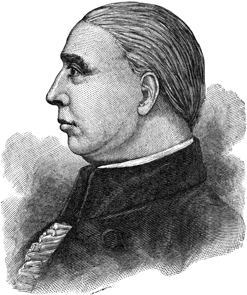
America’s first Survey General was none only than Rufus Putnam, one of the co-founders of the Ohio Company of Associates. He was the one I mentioned last week who gathered with his friends at the Bunch-of-Grapes tavern in Boston ten years earlier in 1786 – just one year after Jefferson negotiated the Land Ordinance of 1785. They drafted a plan for how to profit from the settlement in the Ohio territories, sent it to their friends in Congress to enact, and here Putnam was in charge of surveying and platting land ceded by force so that he, his buddies, and the United States could profit. Clear evidence of just how intertwined crony capitalism, cartesian cartography, Christianity, and White supremacy are rooted in the American government and military.
Jefferson’s dream was finally coming true. The U.S. government was just hitting its stride. They now had an organized and methodical means of measuring and dissecting land for sale to citizens seeking land settlement and companies seeking financial settlement. All so the United States could amass a larger military as they headed west into the sunset, charting meridians on a map as they marched toward global domination.
Roxanne Dunbar-Ortiz. An Indigenous Peoples’ History of the United States. P. 81
ibid.
ibid.
C. Albert White. A History of the Rectangular Survey System.


.jpg)